
Understanding Dry Storms: A Hidden Threat in a Warming World
Imagine a storm that roars with thunder and crackles with lightning, yet no rain falls. Dark clouds loom over a landscape already parched by days of extreme heat, while lightning streaks across the sky without the relief of precipitation. This is not a scene from a science fiction film but a real-world phenomenon known as a dry storm.
These weather events, often mistaken for harmless due to their lack of rainfall, are among the most dangerous natural causes of wildfires globally. Their deceptive nature masks a complex set of atmospheric processes that, when combined with increasingly frequent and intense heatwaves driven by climate change, create conditions ripe for disaster.
The Paradox of the Electric Sky
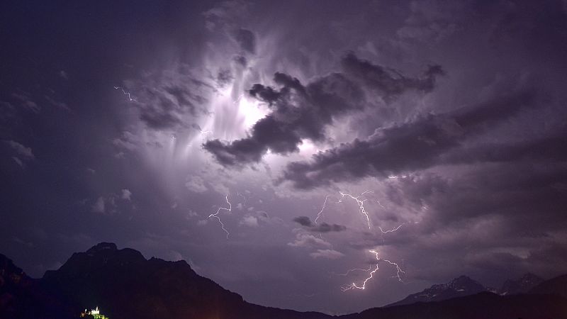
A dry storm is characterized by intense electrical activity, such as thunder and lightning, but little or no precipitation reaching the ground. This creates a paradox: the term "dry" refers only to what happens at the surface, not the processes within the storm cloud itself.
From an atmospheric physics perspective, all storms start as "wet" phenomena. They form through the condensation of water vapor and generate precipitation like any other thunderstorm. However, in a dry storm, the rain or hail formed in the upper layers encounters a layer of extremely dry and warm air as it descends. This "invisible barrier" causes the precipitation to evaporate completely before touching the ground.
One of the most visible signs of a dry storm is the presence of virga—filaments or curtains of precipitation that hang from the base of clouds but disappear into the air before reaching the ground. Known colloquially as "ghost rain," this phenomenon is a clear indicator of a potentially dangerous storm.
Dry storms are also marked by powerful wind gusts, known as "blowdowns," which can exceed 100 km/h. These winds contribute to the overall danger of these events, making them more than just a visual spectacle.
Heat Waves and the Perfect Fuel
The relationship between dry storms and heat waves is more than coincidental; it's a dangerous synergy that sets the stage for large-scale disasters. Heat waves play a crucial role in preparing the atmosphere for dry storms.
First, they create atmospheric instability. Intense and persistent heat generates powerful updrafts that feed the formation of storm clouds. At the same time, high temperatures create a vertical structure where warm air sits at the surface and dry air lies at mid-levels, creating ideal conditions for rain to evaporate before reaching the ground.
Heat waves also transform the landscape into a tinderbox. Prolonged periods of extreme heat and low humidity dehydrate vegetation, dry out soil, and reduce moisture content in forest fuels to dangerously low levels. This process turns entire regions into volatile environments that require only a spark to ignite.
In some cases, dry storms can even trigger "heat bursts"—powerful downdrafts that rapidly warm due to compression, causing sudden temperature spikes of over 10°C within minutes, often accompanied by hurricane-force winds.
Climate Change and the Growing Risk
Global warming is intensifying the dangerous connection between heat waves and dry storms. A warmer atmosphere holds more water vapor, increasing the intensity of the hydrological cycle. While this leads to more intense rainfall in some areas, it also accelerates evaporation. In arid regions like the Mediterranean, this results in more severe droughts and flammable landscapes.
Climate models suggest that heat waves will become more frequent, intense, and longer-lasting due to climate change. This creates the perfect conditions for dry storms to become the new summer norm.
The Dangers of a Deceptive Storm
The absence of rainfall in dry storms can give a false sense of security. Beneath their seemingly harmless appearance, however, lies a chain reaction of interconnected dangers that can be far more serious than they appear.
The most direct threat is dry lightning—cloud-to-ground lightning strikes that occur without the protective cover of rain. Lightning can heat the surrounding air to over 30,000°C, and when it strikes vegetation dried by heat, ignition is almost immediate.
Unlike wet storms, which often extinguish small fires with subsequent rain, dry storms allow fires to spread unchecked. Smoldering fires may burn slowly for hours or even days before erupting suddenly when conditions change.
Dry storms can also produce blowdowns—intense downdrafts capable of generating straight-line winds exceeding 120 km/h. These winds can topple trees, damage infrastructure, and, in wildfire conditions, act like massive bellows, rapidly fanning flames and triggering explosive fire spread.
Another major risk is the deterioration of air quality. Powerful winds can stir up dust and sand, creating hazardous conditions with reduced visibility. Fires ignited by dry lightning also release smoke filled with fine particles that can enter the bloodstream, posing serious health risks.
This smoke can travel hundreds of kilometers, affecting air quality in distant cities. The true danger lies in how these threats interconnect: lightning ignites the fire, powerful winds escalate it into a firestorm, and together they unleash an air quality crisis that can last for weeks and impact millions of people.
A Historical Example
Spain experienced a vivid example of this phenomenon in 1979 in the Ayora-Enguera region of Valencia. During an intense heatwave, a fire sparked by dry lightning burned through approximately 44,000 hectares. This event remains a historical illustration of the destructive chain reaction that climate change is increasingly turning into a reality for vulnerable areas like the Mediterranean.